2. THEY CALL IT HOME
2.1 Geography an climate
The Andaman archipelago consists of more than 200 islands covering an area of 8300 sq.km (3200 sq.miles), somewhat smaller than Cyprus or Puerto Rico. Sometimes called collectively the Bay islands by the Indians, the sister archipelagoes of the Andamans and Nicobars form an arc across the Bay of Bengal from Burma in the north to the Indonesian island of Sumatra in the south. They lie nearly parallel to the coast of Burmese Tenasserim, the coastal Mergui archipelago and the Thai mainland, roughly 600 km (370 miles) to the east. The Indian coast at Madras is nearly double (1100 km or 700 miles) this distance to the west.
Despite their coral reefs, most Andamanese islands themselves are not of coral origin. Instead they are the peaks of a drowned mountain range. While there is only a narrow littoral, there are some shallow banks off the coasts of the Great Andamans, especially to the northwest and southeast. When the level of the sea was lower than today, these could have formed islands. North Sentinel island and Little Andaman are exceptional as they are relatively flat and mostly of coral origin. The other major islands are hilly with the archipelago's highest point at Saddle Peak on North Great Andaman. This hill, with its 738 m (2400 ft), might not look impressive but it has been called the most difficult mountain of his career by a famous Himalayan mountain climber and explorer. He found the slippery rocks, the thorny flora and the clawed, stinged and poisonous fauna almost too much for him. The area around Saddle Peak was one of the few areas avoided by all the aboriginal tribes. They thought it haunted by evil spirits and dangerous animals. The first recorded ascent of the hill was claimed in 1882 by one Major Protheroe of the British army who showed a lamentable lack of sportsmanship: Indian convicts had to cut a path through the vegetation to the top before he and his fellow officers could made their ascent to claim a first.
The monsoonal climate of the Andamans is generally hot and always humid, of-ten oppressively so. Heavy though rainfall can be, it is quite unpredictable from year to year and can fall most unevenly within a small area. On islands with few perennial streams, a lack of fresh water can quickly become a serious problem. During the time from December to March temperature and humidity tend to be lower and there is less rain but it would be an exaggeration to call it a "dry" sea-son. Violent thunderstorms occur during the wet south-west monsoon from mid-May to end-September while tropical revolving storms (in other areas of the world known as typhoons or hurricanes) usually form to the south, west and north of the Andamans, moving towards India without directly affecting the islands. Very rare-ly a major storm crosses the islands, leaving appalling damage behind. Luckily, the islands have not suffered such a major event for the past century but they are, statistically speaking, worryingly overdue for a heavy blow. Several major storms hit the islands during the 19th century, leaving whole areas of jungle flat-tened. At such times, despite the mountainous waves, the only place for the abo-riginal population safe from falling trees and flying debris was the open sea and their wide beaches. The damage caused by a severe storm need not be limited to the land: huge waves whipped up over the deep Andaman sea hit the narrow littoral of the archipelago with tremendous and unbroken force, destroying coral reefs, shifting beaches and removing mangrove swamps. Extensive underwater deserts - areas covered with dead and broken coral - have been found around the archipelago. Under these circumstances it is hardly surprising to find that rain, wind and the weather generally are at the centre of aboriginal religious beliefs.
2.2 Plate tectonics
Geologically, the Andamans and Nicobars represent the highest peaks of an un-der-water mountain range which is itself an extension of the Arakan range in Burma and the Sumatran Barisan ranges to the south. The islands lie parallel to a geological fault line to the east, crossing the Andaman sea from north to south. The line marks two tectonic plates rubbing against each other: the eastern plate, an extension of the huge Eurasian plate, is stationary, while the Indian plate to the west is moving north to northeast at the rate of a few centimetres a year, tak-ing the Andaman Islands with it. This slow but steady movement is still pushing up the Himalayan Mountains and causes earthquakes and volcanic activity in and around the islands. India's only active volcanoes, on Barren and Narcondam islands, are sitting directly on the fault line. The Andamans are rising and falling with the erratic local movement of the earth's crust. On a geological time-scale these are mere shudders, small and rapid. On a human time-scale, however, the shudders have been very slow but some were still rapid enough to have adverse-ly affected human life during the geological instant Homo sapiens sapiens has been in residence. While the large-scale geological trend still continues to cause a slow rising of the Andamans, (10) in the relatively short term of a few thousand years, the islands have both sunk and risen. On the still shorter timescale of a few hundred years and quite independently of any geological movements, the sea has also been rising and falling. The interaction of all these movements has resulted in a complex rising and falling, a growing and shrinking of the land area available to the original Andamanese population.
The present geological era is the Cenozoic. It started around 65 millions years ago with the end of the Cretaceous period, a major event that caused mass ex-tinctions among the earth's life forms, including most famously the dinosaurs. Modern humans, including of course the Andamanese, developed during the later part of the Pleistocene, i.e. very recently on a geological time scale.
1.9 En-mai
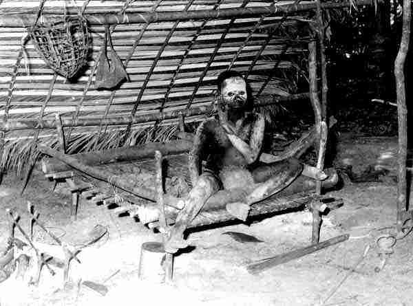
The injured Jarawa boy En-mai mentioned earlier plays a peculiar role in the tragedy. After his release from hospital, he disappeared for a while and then reappeared among other Jarawa visitors. He became the pet of the Bush police, who allow him to be photographed and even interviewed in return for substantial gifts to themselves. He is the only (but probably not the last) Jarawa to wear western teenage-style clothing right down to the reversed baseball cap. It can only have been this boy who told his fellow Jarawa of the rich and effortless pickings to be had in the outside world. His hospital experience must have convinced him that if you can't beat them, join them. He is a natural leader, at least over the younger generation of Jarawa. Older people are noticeably absent from the drive "into town" and one astute obeserver has noted that after En-mai had returned for a while to his parents in the jungle he seemed to be sad and disturbed, although he would not say why. Later reports claimed that the older people did not approve of the youngsters' trip to town and that there were tensions between the generations. Welcome to the modern world, Jarawas!
After 2000, En-mai has become the centre of a cargo-cult like "movement" - he can bring in the goodies that the Port Blair government has spread among Jarawa until the recent court decision stopped such shenanigans. It is not yet clear how he will rescue his position with the source of his supplies cut off. Perhaps it will only be cut off officially. En-mai also now stands accused of having murdered the man he suspected to be the lover of his wife. Clearly, contact with the often quoted "civilized mainstream society of India" has not been good for poor En-mai.